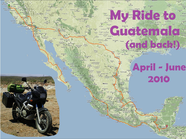


 Day 24: Today I backtracked a little -- I left from Aquismon back up north. My goal was to see the Tamul waterfall, which is around 100 meters high.
 They now (since I was last here in '08) have these highly graphical tourists signs all over the area here, which make it very easy to find the natural attractions, since each sign tells you not only what is right where you are, but has arrows pointing which way to see other stuff in the area. In Aquismon my GPS showed an "unpaved road" as the direct route north to Tamul, vs the long way around on the highway (50 miles longer). The colorful sign in Aquismon, though, pointed the "unpaved road" as the way to Tamul. So I took that, and found it was fully paved, and a wonderful ride through lightly traveled farmlands.
I passed a group of 4 vaqueros, their white cowboy hats shining brightly in the sun, riding atop horses, herding a group of cattle off in a field. I waved at them from the saddle of my own iron horse, and they waved back. I also saw a basketball hoop at what I assume was a religious school, because they were able to make it look like a cross!
I arrived at the river to see Tamul, where you have to pay to rent a boat and they paddle you 4 kilometers upriver to see the waterfalls themselves. I got in with a group of 4 Mexicans, and paid 200 pesos ($16) for my share. There were hordes of people doing this; the river was a madhouse of boats going up and down. When we finally came within view of the falls themselves, we stopped at a rock in the water a considerable distance away. Click here to see us rounding the final corner for the first view of the falls. It was fine for a photo shot, but I wanted to be much closer! The guides let us all take a photo, but then hurried us back into the boat to leave, as more boats were arriving. Needless to say, I was a bit disappointed at the experience. Midway back down the river, we stopped at some crowded tourist shacks, to buy refreshments (I had more mango with chili powder & lime juice, my favorite).
When I left back on the bike, I continued riding up the road towards Tamasopo, where I'll spend the night. I then came across another graphical sign for Tamul, this one telling me of an overlook. "More interesting!" I thought. 5 kilometers down a rough rocky road, I reached a campground. I paid 10 pesos ($0.80) at the gate, and followed a windy trail for 10 minutes, straight out to the top of the waterfall! Literally, you could go stand in the middle at the very top if you wanted. But be careful -- it's a 350 foot drop. There were only 4 people there with me, off swimming in one of the many gorgeous , crystal clear turquise pools. Click here to see a video of the view from right at the top.
Then, I found some rickety bamboo ladders, leading down, which I decided to follow. They lead me right to the base of the falls themselves! There was no one else here, and I had all the time I wanted. What a much better experience! And for 10 pesos, instead of 200...
Awesome find! By the way you look fantastic in these pictures.
ReplyDeleteThanks for the compliment Michelle! And Happy Birthday to Sierra tomorrow, in case I forget to write (she's 7 now... time for her own e-mail?? :)
ReplyDelete